TOPOGRAPHY OF THE SOUTHERN PART OF BOLGARY SITE (METHODS OF CONSTRUCTIONS SEARCH AND INTERPRETATION)
Keywords:
Bolgary site, Golden Horde, old maps, cosmic photos, geophysical methods, georadar, magnetometry, historical topography, monumental buildings, mausoleum, fountainAbstract
Low effi ciency of architectural constructions by geophysical methods provokes necessity of the other methods application. The absence here of modern rural buildings and simple way to identify the traces of latest land-utilization ensure eff ective of cosmic photos and its comparison to old maps of the site. The critical approach to the both groups of the sources in important. The traces of last fields and communications on cosmic photos must be discarded. Old maps of the site (sometimes very inaccurate) frequently have no full explication of objects or more important give incorrect explanation. By the last years some constructions that are signed on maps and visible on cosmic photos were explored in the periphery of the site (excavations CLXXIV, CXCIV, CCI, CCII, CCIII, CCXIV).
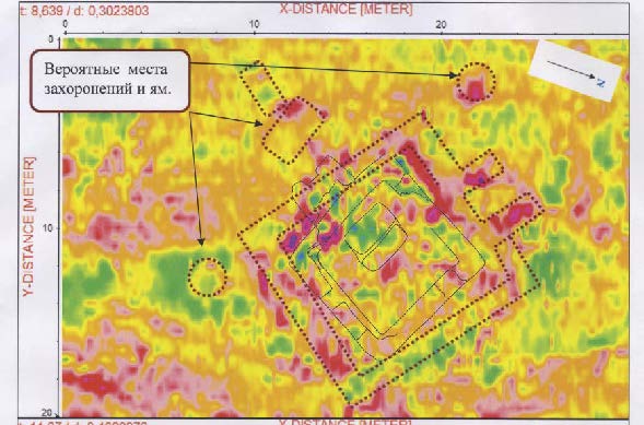
There are few unidentifi ed constructions available excluding wells. The map accompanying report by prince Meszsherskyi (1776) was misdated to 19th c. (Map for economic village Bolgary…). It fi xes f pit or building near south–west urban gate (fi g. 7). Small building near mausoleum №5 (excavation LXXXVIII) may be identifi ed confi dently. Incomplete explication for the most detailed maps (group by Strauss – Ritter) conditioned diffi culties in interpretation. May be some objects on them are duplicated. Discovery of some monumental constructions else is possible, but it may be confi rmed by excavation only.
References
Абдуллин Х.М., Баранов В.С., Бугров Д.Г. Ситдиков А.Г. Музей болгарской цивилизации. Т. 3. Открытие древнего Болгара. Казань: Главдизайн, 2016. 254 с.
Калачов Н.В. Рапорт Правительствующему Сенату о месте для добывания селитры при селе Болгарах; всеподданнейший доклад о сем Сената и резолюция императрицы Екатерины // Сборник археологического института / Ред. Н.В. Качалов. СПб.: Археологический институт (Типогр. правит. Сената), 1879. Кн. 2. Отд. I. С. 96–101.
Риттих А.Ф. Материалы для этнографии России. Казанская губерния XIV–тая. Казань: Имп. Казанский университет, 1870. Ч. I. X, II, 110 с., 3 л. карт, 4 л. рис.
Ситдиков А.Г., Сивицкий М.В., Беляев А.В., Хазиев А.И. // Археологические исследования 2015 г.: Болгар и Свияжск / Авторы–сост. А.Г. Ситдиков, Р.Р. Валиев, А.С. Старков. Казань: ЗАО «Издательский дом «Казанская недвижимость», 2016. С. 23−24.
Downloads
Published
How to Cite
Issue
Section
License
Copyright (c) 2018 I. V. Volkov

This work is licensed under a Creative Commons Attribution-NonCommercial 4.0 International License.