RESULTS OF TOPOGRAPHIC-GEODESIC AND CARTOGRAPHIC WORKS IN THE AREA OF BILYAR SETTLEMENT
Keywords:
geodesy, archeological monuments, settlements, Bilyar area, topographic plans, 3D-reconstructionsAbstract
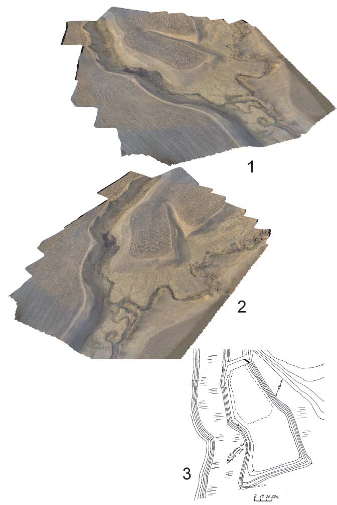
The article presents the results of topographic-geodesic and cartographic works, including surveying with the use of UAV conducted in 2016-2018 at medieval settlement in Bilyar area. Apart from clarifying the information on previous studies, the obtained materials became a foundation for the creation of detailed topographic plans and digital 3D-reconstructions of historical monuments. The
publication illustrates graphical materials of eleven sites located in the Central Trans-Kama Region of the Republic of Tatarstan: Gorkinskoe I and II, Krescheltanskoe, Nikolaev-Baranskoe I, Starotatadamskoe, Savgachevskoe, Savrushinskoe (Atlashkinskoe), Starokamkinskoe, Scherbenskoe I and II settlements, “Svyatoi klyuch settlements (Shelom I, also known as “Svyatoi klyuch” Sanctuary)” and “Svyatoi klyuch (Shelom II)”.
References
Быков Л.В., Быков А.Л., Лашов М.В., Татаурова Л.В. Геодезическое обеспечение археологических исследований // Вестник Омского университета. 2012. № 3 (65). С. 85−93.
Губайдуллин А.М. Фортификация городищ Волжской Булгарии. Казань: ИИ АН РТ, 2002. 232 с.
Свод памятников археологии Республики Татарстан / отв. ред. Ф.Ш. Хузин, А.Г. Ситдиков. Казань, 2007. 528 с.
Фахрутдинов Р.Г. Отчет III отряда археологической экспедиции о разведочных работах, проведенных в 1964 году. – Казань, 1965 / Архив ИА РАН. Р-1, № 2928. – 194 л.
Шакиров З.Г. История изучения археологических памятников в округе Билярского городища // Труды Камской археолого-этнографической экспедиции. Вып. VIII: Археологические памятники Поволжья и Урала: современные исследования проблемы сохранения и музеефикации: сб. науч. тр. / под общ. ред. А.М. Белавина; Перм. гос. гуманит.-пед. ун-т. Пермь, 2012, С. 276−283.
Шакиров З.Г. Средневековая округа Биляра: к методике исследования поселенческой структуры и ресурсного потенциала // ПА. 2014. №2 (8). С. 37−48.
Шакиров З.Г., Хузин Ф.Ш. Комплексные исследования Билярской археологической экспедиции // ПА. 2018. № 2 (24). С. 85−99.
Downloads
Published
How to Cite
Issue
Section
License
Copyright (c) 2018 G.Kh. Vafi na, L.V. Ovechkina, Z.G. Shakirov

This work is licensed under a Creative Commons Attribution-NonCommercial 4.0 International License.