NEW DATA ON THE TOPOGRAPHY OF SELITRENNOE SETTLEMENT
DOI:
https://doi.org/10.24852/2587-6112.2021.3.269.272Keywords:
archaeology, Golden Horde, Selitrennoe settlement, Saray al-Jedid, topography, chronology, necropolis, ceramicsAbstract
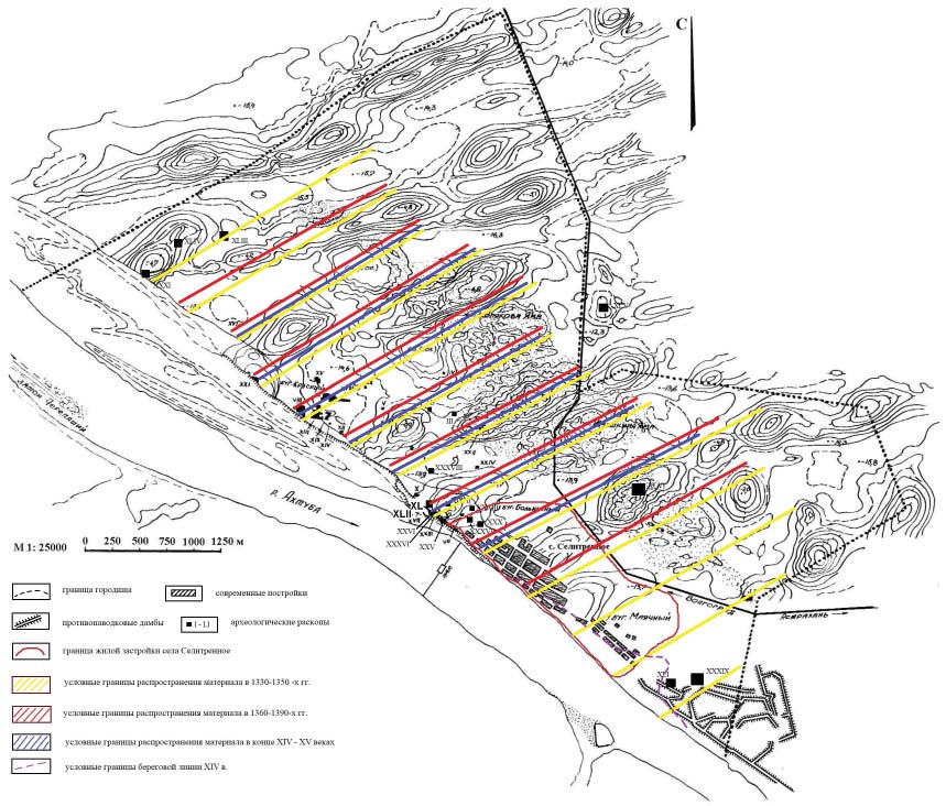
The paper discusses the issues related to the topography of Selitrennoe settlement, which is the remains of the Golden Horde capital of Saray al-Jedid. A brief description of the works by F.V. Ballod and V.G. Rudakov concerned to the study of the topography and chronology of the monument is provided by the author. The information obtained in 2019–2020 in the course of archaeological studies in the territory of Selitrennoe village is presented, which complements and corrects the conclusions of the colleagues.
References
Ballod, F. V. 1923. Stariy i Noviy Saray, stolitsy Zolotoy Ordy (Old and New Sarai, Capitals of the Golden Horde). Kazan: “Kombinat Izdatel'stva i Pechati v Kazani” Publ. (in Russian).
Pigarev, E. M. 2019. Selitrennoe gorodishche: istoriia issledovanii (Selitrennoe Settlement: Study History). Series: Materialy i issledovaniia po arkheologii Povolzh’ia (Materials and Research on the Archaeology of the Volga Region) (11). Yoshkar-Ola: Mari State University (in Russian).
Rudakov, V. G. 2007. Selitrennoe gorodishche: khronologiia i topografi ia (Selitrennoe Settlement: Chronology and Topography). Diss. of Candidate of Historical Sciences. Moscow. Archive of Lomonosov Moscow State University. 61: 07-7/454 (in Russian).
Downloads
Published
How to Cite
Issue
Section
License
Copyright (c) 2021 E.M. Pigarev

This work is licensed under a Creative Commons Attribution-NonCommercial 4.0 International License.